当前位置:网站首页>GeoServer introductory learning: 05-Multi-level MBTiles specification data release
GeoServer introductory learning: 05-Multi-level MBTiles specification data release
2022-08-08 21:02:00 【Bare feet thinking】
I. Opening
This article demonstrates how to publish multi-level MBTiles data in GeoServer. Before publishing, you need to configure the MBTiles extension package. If the WPS extension package is not configured, you need to configure it together.
As shown in the figure above, GeoServer does not include the MBTiles extension package by default. Therefore, there is no entry for publishing MBTiles data in "New Data Source".

Second, download the WPS extension package
1. As shown in the figure below, in order for the MBTiles extension package to be used normally, make sure that the WPS extension package has been installed successfully before installation.

2. Next, download the WPS extension package from the official website, which needs to match the currently installed GeoServer version, the currently installed GeoServer version: 2.16.0
Official website download address: https://sourceforge.net/projects/geoserver/files/GeoServer/2.16.0/extensions/

Once you find the expansion pack, click to download it.
You can also download the expansion pack from Baidu Netdisk: https://pan.baidu.com/s/13TUrgaTB6Q0v2l6UwubinQ Extraction code: r7wv
Reminder: Be sure to note that the downloaded plug-in package is the same as the GeoServer version, otherwise it may not be available, or an abnormal situation may occur.
Three, install the WPS extension package
1. The expansion package has been downloaded, unzip it, as shown below:

2. As shown in the figure above, copy the six jar packages extracted to the GeoServer installation path webapps\geoserver\WEB-INF\lib folder, as shown in the following figure:

If some files already exist, the following prompt box will pop up:

Indicates that some files already exist in the folder. You can choose to keep the original files or replace them with the latest copied files.
3. At this point, the WPS extension package has been installed, and you can install and configure the MBTiles extension package.
Fourth, download the MBTiles extension package
Similarly, download the MBTiles extension package that matches the currently installed GeoServer version from the official website.Our current installation is GeoServer version 2.16.0.
Open the official page: https://docs.geoserver.org/stable/en/user/community/mbtiles/installing.html

Click the hyperlink page shown above to open the specific download page: https://build.geoserver.org/geoserver/2.16.x/community-latest/

Click the hyperlink of geoserver-2.16-SNAPSHOT-mbtiles-plugin.zip above to download, the full address of the link is: https://build.geoserver.org/geoserver/2.16.x/community-latest/geoserver-2.16-SNAPSHOT-mbtiles-plugin.zip
If you can't download it, you can download it through Baidu network disk: https://pan.baidu.com/s/1MaFPJgUewVA4g0tDB3RPdQ Extraction code: 1ouc
After copying this content, open the Baidu SkyDrive mobile app, which is more convenient to operate.
Warm reminder: Be sure to pay attention to the same version of the downloaded plug-in package as GeoServer, otherwise it may not be available, or an exception occurs.
V. Install the MBTiles extension package
1. The expansion package has been downloaded, unzip it, as shown below:

2. As shown in the figure above, copy the decompressed 3 jar packages to the GeoServer installation path webapps\geoserver\WEB-INF\lib folder, as shown in the following figure:

If some files already exist, the following prompt box will pop up:

Indicates that some files already exist in the folder. You can choose to keep the original files or replace them with the latest copied files.
3. Restart GeoServer, and then open the "Add Data Source" page.

As shown in the figure above, you can see that there is already an entry for publishing MBTiles. Click the entry link to publish multi-level MBTiles data.
Six. References
1. GeoServer publishes basemap slicing services such as multi-level sky maps, Google maps, and AutoNavi maps: https://blog.csdn.net/zhengjie0722/article/details/100034677
2. GeoServer publishes multi-level map data (large image mosaic/MBTilers specification): https://blog.csdn.net/u013592964/article/details/53337968
边栏推荐
猜你喜欢


随机推荐
新库上线 | CnOpenDataA股上市公司基本信息数据
去噪论文 Beyond a Gaussian Denoiser: Residual Learning of Deep CNN for Image Denoising
Flask 教程 第七章:错误处理
The new database is online | CnOpenData information transmission, software and information technology service industry basic information data of industrial and commercial registered enterprises
fashion CNNs code
GeoServer入门学习:07-发布多层级TIF地图大图数据
Flask 教程 第十一章:美化
去噪论文 Attention-Guided CNN for Image Denoising
fastapi-实战-综述
SQL-堆叠注入(含例题)
GeoServer入门学习:05-多层级MBTiles规范数据发布
磁控胶囊胃镜:具有良好耐受性的非侵入性胃镜检查
Gradle is as simple as using kotlin to write common commands
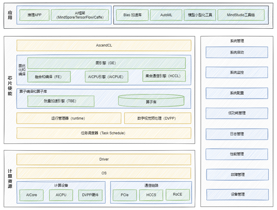
昇腾Ascend 随记 —— 昇腾 AI 的基本架构
【JVM内存区域】
我们仍未知道那天踩的MultipartFile file为null的大坑是为什么
第十三届蓝桥杯(Web 应用开发)线上模拟赛【第十题】(RESTful API 开发)
【线性代数04】投影矩阵P和标准正交矩阵Q
wp-ctfshow-web10 (group up注入)
Some useful frameworks in Kotlin