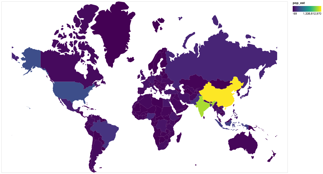
gpdvega is a bridge between GeoPandas and Altair that allows to seamlessly chart geospatial data

Overview

gpdvega Coverage Status Build Status HitCount GitHub license GitHub issues

gpdvega is a bridge between GeoPandas a geospatial extension of Pandas and the declarative statistical visualization library Altair, which allows to seamlessly chart geospatial data using altair.

Example

import altair as alt
import geopandas as gpd
import gpdvega

alt.renderers.enable('notebook') # render for Jupyter Notebook

world = gpd.read_file(gpd.datasets.get_path('naturalearth_lowres'))

# GeoDataFrame could be passed as usual pd.DataFrame
alt.Chart(world[world.continent!='Antarctica']).mark_geoshape(
).project(
).encode(
    color='pop_est', # shorthand infer types as for regular pd.DataFrame
    tooltip='id:Q' # GeoDataFrame.index is accessible as id
).properties(
    width=500,
    height=300
)

output

Install

Dependencies

gpdvega requires:

  • Altair (>= 2.2.0 )
  • GeoPandas (>= 0.4.0)

User installation

using pip

pip install gpdvega

Changelog

See the changelog for a history of notable changes to gpdvega

Python script that can be used to generate latitude/longitude coordinates for GOES-16 full-disk extent.

goes-latlon Python script that can be used to generate latitude/longitude coordinates for GOES-16 full-disk extent. 🌎 🛰️ The grid files can be acces

Douglas Uba 3 Apr 06, 2022
pure-Python (Numpy optional) 3D coordinate conversions for geospace ecef enu eci

Python 3-D coordinate conversions Pure Python (no prerequistes beyond Python itself) 3-D geographic coordinate conversions and geodesy. API similar to

Geospace code 292 Dec 29, 2022
Helping data scientists better understand their datasets and models in text classification. With love from ServiceNow.

Azimuth, an open-source dataset and error analysis tool for text classification, with love from ServiceNow. Overview Azimuth is an open source applica

ServiceNow 145 Dec 23, 2022
Tools for the extraction of OpenStreetMap street network data

OSMnet Tools for the extraction of OpenStreetMap (OSM) street network data. Intended to be used in tandem with Pandana and UrbanAccess libraries to ex

Urban Data Science Toolkit 47 Sep 21, 2022
r.cfdtools 7 Dec 28, 2022
Documentation and samples for ArcGIS API for Python

ArcGIS API for Python ArcGIS API for Python is a Python library for working with maps and geospatial data, powered by web GIS. It provides simple and

Esri 1.4k Dec 30, 2022
Python module to access the OpenCage geocoding API

OpenCage Geocoding Module for Python A Python module to access the OpenCage Geocoder. Build Status / Code Quality / etc Usage Supports Python 3.6 or n

OpenCage GmbH 57 Nov 01, 2022
GeoNode is an open source platform that facilitates the creation, sharing, and collaborative use of geospatial data.

Table of Contents What is GeoNode? Try out GeoNode Install Learn GeoNode Development Contributing Roadmap Showcase Most useful links Licensing What is

GeoNode Development Team 1.2k Dec 26, 2022
ArcGIS Python Toolbox for WhiteboxTools

WhiteboxTools-ArcGIS ArcGIS Python Toolbox for WhiteboxTools. This repository is related to the ArcGIS Python Toolbox for WhiteboxTools, which is an A

Qiusheng Wu 190 Dec 30, 2022
This app displays interesting statistical weather records and trends which can be used in climate related research including study of global warming.

This app displays interesting statistical weather records and trends which can be used in climate related research including study of global warming.

0 Dec 27, 2021
Earthengine-py-notebooks - A collection of 360+ Jupyter Python notebook examples for using Google Earth Engine with interactive mapping

earthengine-py-notebooks A collection of 360+ Jupyter Python notebook examples for using Google Earth Engine with interactive mapping Contact: Qiushen

Qiusheng Wu 1.1k Dec 29, 2022
a Geolocator made in python

Geolocator A Geolocator made in python ✨ Features locates ur location using ur ip thats it! 💁‍♀️ How to use first download the locator.py file instal

Portgas D Ace 1 Oct 27, 2021
GeoIP Legacy Python API

MaxMind GeoIP Legacy Python Extension API Requirements Python 2.5+ or 3.3+ GeoIP Legacy C Library 1.4.7 or greater Installation With pip: $ pip instal

MaxMind 230 Nov 10, 2022
This program analizes films database with adresses, and creates a folium map with closest films to the coordinates

Films-map-project UCU CS lab 1.2, 1st year This program analizes films database with adresses, and creates a folium map with closest films to the coor

Artem Moskovets 1 Feb 09, 2022
Cloud Optimized GeoTIFF creation and validation plugin for rasterio

rio-cogeo Cloud Optimized GeoTIFF (COG) creation and validation plugin for Rasterio. Documentation: https://cogeotiff.github.io/rio-cogeo/ Source Code

216 Dec 31, 2022
When traveling in the backcountry during winter time, updating yourself on current and recent weather data is important to understand likely avalanche danger.

Weather Data When traveling in the backcountry during winter time, updating yourself on current and recent weather data is important to understand lik

Trevor Allen 0 Jan 02, 2022
Construct and use map tile grids in different projection.

Morecantile +-------------+-------------+ ymax | | | | x: 0 | x: 1 | | y: 0 | y: 0

Development Seed 67 Dec 23, 2022
Enable geospatial data mining through Google Earth Engine in Grasshopper 3D, via its most recent Hops component.

AALU_Geo Mining This repository is produced for a masterclass at the Architectural Association Landscape Urbanism programme. Requirements Rhinoceros (

4 Nov 16, 2022
A public data repository for datasets created from TransLink GTFS data.

TransLink Spatial Data What: TransLink is the statutory public transit authority for the Metro Vancouver region. This GitHub repository is a collectio

Henry Tang 3 Jan 14, 2022
Manipulation and analysis of geometric objects

Shapely Manipulation and analysis of geometric objects in the Cartesian plane. Shapely is a BSD-licensed Python package for manipulation and analysis

3.1k Jan 03, 2023