Using Global fishing watch's data to build a machine learning model that can identify illegal fishing and poaching activities through satellite and geo-location data.

Overview

Catching-Illegal-Fishing

Using Global fishing watch's data to build a machine learning model that can identify illegal fishing and poaching activities through satellite and geo-location data.

Global fishing watch is a partnership between Google and Oceana to map all trackable fishing activity in world, in almost real time. This is a personal project using the data provided by global fishing watch.

The data provided has vessel ids, types and coordinates of encountered vessels.

Given same vessel type and are, a fishing vessel has a different trajectory than a non fishing vessel. I used the data provided to train my model on predicting whether a vessel is fishing or not.

#Local Environment Setup Python 3.7++ Tensorflow version >1.14.0,<2.0 from (https://www.tensorflow.org/get_started/os_setup) pip install google-api-python-client pyyaml pytz newlinejson python-dateutil yattag

#Model Result image

image

image

image

image

image

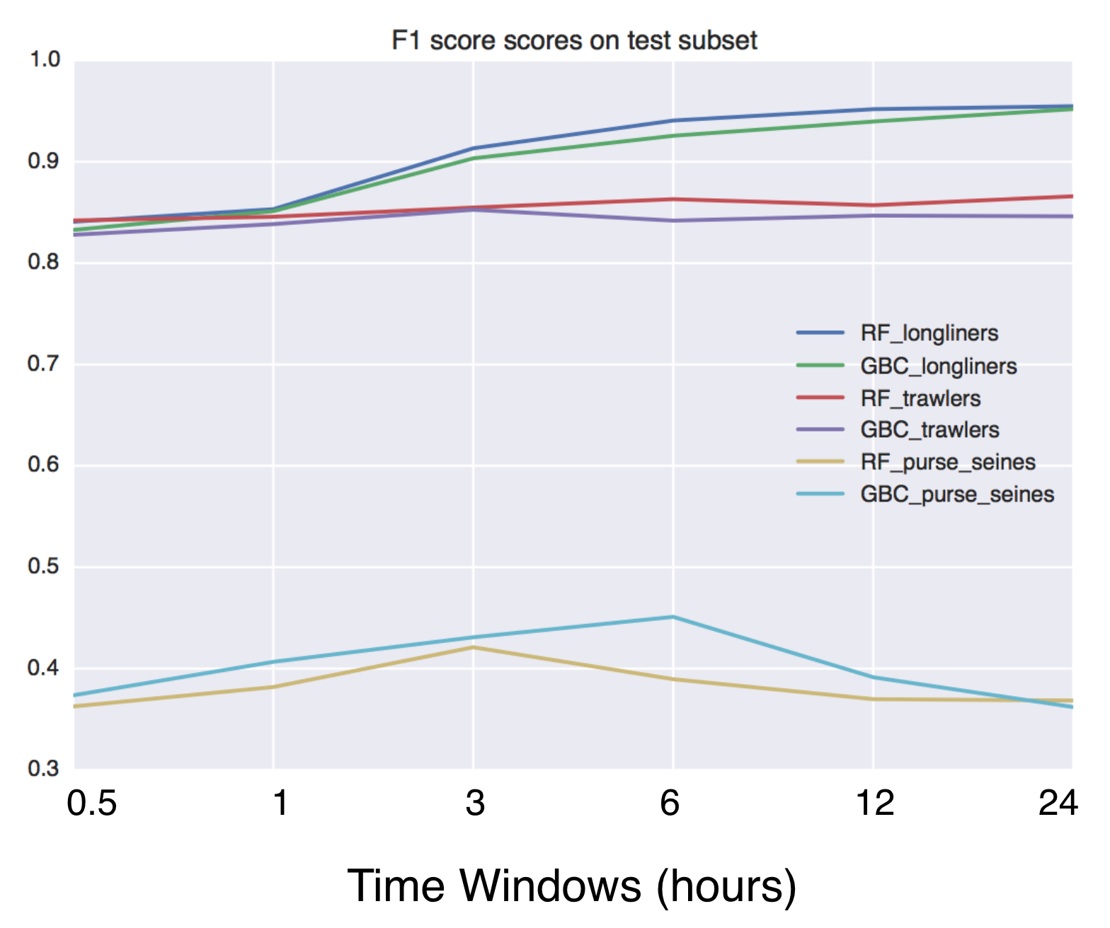
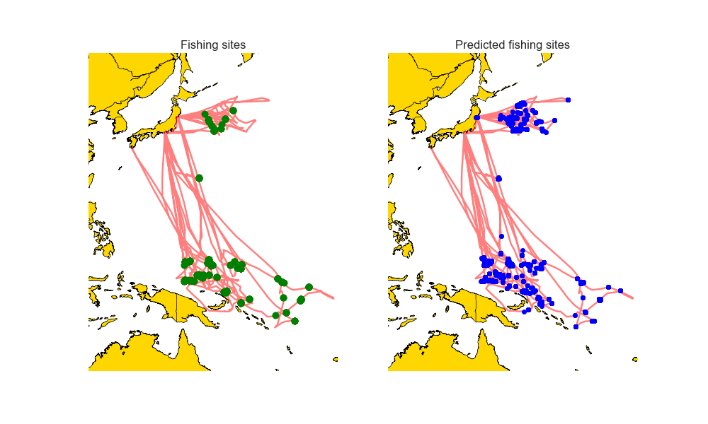
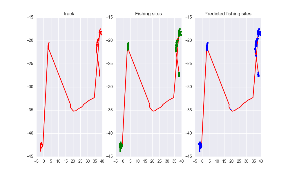
As you can see the predicted tracks are extremely close to the real paths.

Owner
Ayush Mishra
Machine Learning enthusiast.
Ayush Mishra
Python tools for geographic data

GeoPandas Python tools for geographic data Introduction GeoPandas is a project to add support for geographic data to pandas objects. It currently impl

GeoPandas 3.5k Jan 03, 2023
A Python framework for building geospatial web-applications

Hey there, this is Greppo... A Python framework for building geospatial web-applications. Greppo is an open-source Python framework that makes it easy

Greppo 304 Dec 27, 2022
Tile Map Service and OGC Tiles API for QGIS Server

Tiles API Add tiles API to QGIS Server Tiles Map Service API OGC Tiles API Tile Map Service API - TMS The TMS API provides these URLs: /tms/? to get i

3Liz 6 Dec 01, 2021
A short term landscape evolution using a path sampling method to solve water and sediment flow continuity equations and model mass flows over complex topographies.

r.sim.terrain A short-term landscape evolution model that simulates topographic change for both steady state and dynamic flow regimes across a range o

Brendan Harmon 7 Oct 21, 2022
The geospatial toolkit for redistricting data.

maup maup is the geospatial toolkit for redistricting data. The package streamlines the basic workflows that arise when working with blocks, precincts

Metric Geometry and Gerrymandering Group 60 Dec 05, 2022
Raster processing benchmarks for Python and R packages

Raster processing benchmarks This repository contains a collection of raster processing benchmarks for Python and R packages. The tests cover the most

Krzysztof Dyba 13 Oct 24, 2022
Geodata extensions for Django REST Framework

Django-Spillway Django and Django REST Framework integration of raster and feature based geodata. Spillway builds on the immensely marvelous Django RE

Brian Galey 62 Jan 04, 2023
Manipulation and analysis of geometric objects

Shapely Manipulation and analysis of geometric objects in the Cartesian plane. Shapely is a BSD-licensed Python package for manipulation and analysis

3.1k Jan 03, 2023
Google maps for Jupyter notebooks

gmaps gmaps is a plugin for including interactive Google maps in the IPython Notebook. Let's plot a heatmap of taxi pickups in San Francisco: import g

Pascal Bugnion 747 Dec 19, 2022
Wraps GEOS geometry functions in numpy ufuncs.

PyGEOS PyGEOS is a C/Python library with vectorized geometry functions. The geometry operations are done in the open-source geometry library GEOS. PyG

362 Dec 23, 2022
A bot that tweets info and location map for new bicycle parking added to OpenStreetMap within a GeoJSON boundary.

Bike parking tweepy bot app A twitter bot app that searches for bicycle parking added to OpenStreetMap. Relies on AWS Lambda/S3, Python3, Tweepy, Flas

Angelo Trivisonno 1 Dec 19, 2021
Google Maps keeps old satellite imagery around for a while – this tool collects what's available for a user-specified region in the form of a GIF.

google-maps-at-88-mph The folks maintaining Google Maps regularly update the satellite imagery it serves its users, but outdated versions of the image

Noah Doersing 111 Sep 27, 2022
Solving the Traveling Salesman Problem using Self-Organizing Maps

Solving the Traveling Salesman Problem using Self-Organizing Maps This repository contains an implementation of a Self Organizing Map that can be used

Diego Vicente 3.1k Dec 31, 2022
Advanced raster and geometry manipulations

buzzard In a nutshell, the buzzard library provides powerful abstractions to manipulate together images and geometries that come from different kind o

Earthcube Lab 30 Jun 20, 2022
Deal with Bing Maps Tiles and Pixels / WGS 84 coordinates conversions, and generate grid Shapefiles

PyBingTiles This is a small toolkit in order to deal with Bing Tiles, used i.e. by Facebook for their Data for Good datasets. Install Clone this repos

Shoichi 1 Dec 08, 2021
Record railway train route profile with GNSS tools

Train route profile recording with GNSS technology based on ARDUINO platform Project target Develop GNSS recording tools based on the ARDUINO platform

tomcom 1 Jan 01, 2022
Python module and script to interact with the Tractive GPS tracker.

pyTractive GPS Python module and script to interact with the Tractive GPS tracker. Requirements Python 3 geopy folium pandas pillow usage: main.py [-h

Dr. Usman Kayani 3 Nov 16, 2022
Python bindings to libpostal for fast international address parsing/normalization

pypostal These are the official Python bindings to https://github.com/openvenues/libpostal, a fast statistical parser/normalizer for street addresses

openvenues 651 Dec 16, 2022
Enable geospatial data mining through Google Earth Engine in Grasshopper 3D, via its most recent Hops component.

AALU_Geo Mining This repository is produced for a masterclass at the Architectural Association Landscape Urbanism programme. Requirements Rhinoceros (

4 Nov 16, 2022
Python project to generate Kerala's distrcit level panchayath map.

Kerala-Panchayath-Maps Python project to generate Kerala's distrcit level panchayath map. As of now, geojson files of Kollam and Kozhikode are added t

Athul R T 2 Jan 10, 2022