当前位置:网站首页>ArcGIS urban living area land suitability evaluation (I)
ArcGIS urban living area land suitability evaluation (I)
2022-04-23 00:20:00 【YuanYWRS】
To make suitability evaluation, we first need to determine the evaluation factors and their weights ( It is best to refer to the results of relevant papers for the selection of indicators and weights ):
Traffic convenience :0.28
Waterfront environment :0.09
Stay away from industrial areas :0.06
Forest environment :0.07
Urban atmosphere :0.18
Altitude :0.155
slope :0.155
Here we believe that the weight of transportation convenience is the largest , Followed by elevation and slope , It is considered that the weight ratio of forest environment is the smallest .
General steps :(1) Evaluate the suitability of each single factor , Divide into 1~5 level ( It can also be divided into 10 level , Look at your own needs ), Convert to grid data .
(2) Carry out weighted superposition operation on grid data , The parcel represented by each grid will get a comprehensive value .
(3) Grading the comprehensive grid data , Get the suitability evaluation map ( Thematic map ).
1、 Traffic convenience ( It is believed here that the closer to the road , The higher the level , The more convenient , Suitable for human habitation ): The number of levels should also be set according to the needs , It is best to refer to relevant research results .
From the provincial highway 0-500& Distance from County Road 0-250(5 level )
500-1000&250-500(4 level )
1000-1500&500-1000(3 level )
1500-3000&1000-2000(2 level )
3000-&2000-(1 level )
 1: Right click the road data , Open the property sheet .
2: Select by attribute , A choice for a class , You can see that all the data of the dart are selected . 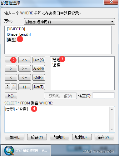
1: Select the type attribute .
2: choice “=”.
3: choice “ Provincial highway ”.
4: Confirmation formula , You can select all the dart elements .

1: Analysis tools , If you don't have this tool in your toolbox , stay gis Right click in the blank space of the , And check the analysis tool , Activate and use .
2: Neighborhood analysis tool .
3: Multi ring buffer , You can also choose other tools , Select the corresponding tools according to the specific needs .
4: Select road features , Here is the provincial highway data .
5: Output address and name ( Be sure to distinguish ).
6: Add this 5 Distance ( Because I divided 5 level ).

1: The unit is meter .
2: Field name selection : Distance from provincial highway , If the field fails to set Chinese , Use English letters to indicate , such as road_distance.
3: choice All.
4: determine .

The generated results are shown in Figure , It can be found that this is a comparison “ smooth ” The scope of the area , The closer to the center, the higher the level , The darker the color .

Similarly, calculate the buffer area of county road , Same operation ( Refer to the above operation ).

The results are shown in the figure above .


Add a new field , Deposit distance, Used to distinguish between the two .
版权声明
本文为[YuanYWRS]所创,转载请带上原文链接,感谢
https://yzsam.com/2022/04/202204230015092401.html
边栏推荐
- 威伦触摸屏和倍福PLC通信报错AdsParseSymbol invalid array index
- (transfer) Aspose Working with document in words Programming Guide
- (transfer) Aspose Documentbuilder II of words Programming Guide
- 倍福常用产品模块型号配置参数
- Antd design pro uses Baidu map, which can be tested in person
- EL2521模块控制步进驱动器
- scanpy find resolution
- 倍福EL5101模块获取光栅尺反馈位置并绑定到NC轴配置
- EXCEL IF函数的简单使用
- Beifu scope view oscilloscope reads the signal of configuration IO
猜你喜欢

How can domestic engine cocos break through the jungle?

Beifu el5101 module obtains the feedback position of the grating ruler and binds it to the NC axis configuration

Implementation method of interface between bar code WMS system and ERP

(transfer) how winscp (SSH FTP client) generates the key to log in Linu

(transfer) Aspose Introduction to DOM tree structure, node class inheritance relationship and description of words Programming Guide
USPS dataset_ Kmeans Usage Summary

componentWillUnmount卸载组件

(transfer) Aspose Documentbuilder I of words Programming Guide
Addition, deletion, modification and query of MySQL table (Advanced)
ArcGIS 城市生活区用地适宜性评价(一)
随机推荐
Why can't people see the facts?
In the b-end / C-end, which is more important, product or operation?
API interface knowledge summary
(transfer) Aspose Words introduction
What kind of community play do you do?
(turn) how is word2016 compatible with MathType
ArcGIS 计算地块容积率
L1-074 finish learning C language in two hours (5 points)
SAP integrated WMS system solution process for large enterprises
cluster_ ACC calculation
What if the website is attacked by DDoS?
Unittest单元测试(六)
Algorithm --- list summation (kotlin)
What are the target keywords?
be based on. NETCORE development blog project starblog - (3) model design
倍福NC轴走速度模式
Node + mongoose paging effect
MySQL安装及基本使用教程
Migrate AWS S3 data to tidb cloud cluster
Shell script notes (5) - conditional statements of this