Program that shows all the details of the given IP address. Build with Python and ipinfo.io API

Overview

ip-details

This is a program that shows all the details of the given IP address. Build with Python and ipinfo.io API

Usage

To use this program, run the main Batch or Shell file, entering an IPv4 address as argument.

$ ip 1.1.1.1

You can also add the --save or -s flag, to save the output to a file. The file will be named details.log, and will be stored inside the saves directory of the program (saves/details.log).

$ ip 1.1.1.1 --save

Or, if prefered:

$ ip 1.1.1.1 -s

Example

$ ip 1.1.1.1

IP : 1.1.1.1
CITY : Miami
REGION : Florida
COUNTRY : US
LOC : 25.7867,-80.1800
ORG : AS13335 Cloudflare, Inc.
POSTAL : 33132
TIMEZONE : America/New_York
MAP : https://maps.google.com/maps/search/25.7867,-80.1800

And with the save option:

$ ip 1.1.1.1 --save

IP : 1.1.1.1
CITY : Miami
REGION : Florida
COUNTRY : US
LOC : 25.7867,-80.1800
ORG : AS13335 Cloudflare, Inc.
POSTAL : 33132
TIMEZONE : America/New_York
MAP : https://maps.google.com/maps/search/25.7867,-80.1800

Data saved to saves/details.log

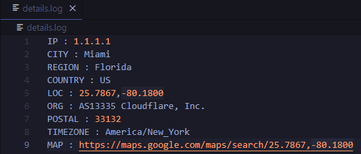
details.log file:

image

Requirements

Python programming language

Requests python library (pip install requests)
Rasterio reads and writes geospatial raster datasets

Rasterio Rasterio reads and writes geospatial raster data. Geographic information systems use GeoTIFF and other formats to organize and store gridded,

Mapbox 1.9k Jan 07, 2023
Solving the Traveling Salesman Problem using Self-Organizing Maps

Solving the Traveling Salesman Problem using Self-Organizing Maps This repository contains an implementation of a Self Organizing Map that can be used

Diego Vicente 3.1k Dec 31, 2022
Python script that can be used to generate latitude/longitude coordinates for GOES-16 full-disk extent.

goes-latlon Python script that can be used to generate latitude/longitude coordinates for GOES-16 full-disk extent. 🌎 🛰️ The grid files can be acces

Douglas Uba 3 Apr 06, 2022
Histogram matching plugin for rasterio

rio-hist Histogram matching plugin for rasterio. Provides a CLI and python module for adjusting colors based on histogram matching in a variety of col

Mapbox 75 Sep 23, 2022
Read images to numpy arrays

mahotas-imread: Read Image Files IO with images and numpy arrays. Mahotas-imread is a simple module with a small number of functions: imread Reads an

Luis Pedro Coelho 67 Jan 07, 2023
PyTorch implementation of ''Background Activation Suppression for Weakly Supervised Object Localization''.

Background Activation Suppression for Weakly Supervised Object Localization PyTorch implementation of ''Background Activation Suppression for Weakly S

34 Dec 27, 2022
Raster processing benchmarks for Python and R packages

Raster processing benchmarks This repository contains a collection of raster processing benchmarks for Python and R packages. The tests cover the most

Krzysztof Dyba 13 Oct 24, 2022
🌐 Local tile server for viewing geospatial raster files with ipyleaflet or folium

🌐 Local Tile Server for Geospatial Rasters Need to visualize a rather large (gigabytes) raster you have locally? This is for you. A Flask application

Bane Sullivan 192 Jan 04, 2023
Tool to suck data from ArcGIS Server and spit it into PostgreSQL

chupaESRI About ChupaESRI is a Python module/command line tool to extract features from ArcGIS Server map services. Name? Think "chupacabra" or "Chupa

John Reiser 34 Dec 04, 2022
Program that shows all the details of the given IP address. Build with Python and ipinfo.io API

ip-details This is a program that shows all the details of the given IP address. Build with Python and ipinfo.io API Usage To use this program, run th

4 Mar 01, 2022
A service to auto provision devices in Aruba Central based on the Geo-IP location

Location Based Provisioning Service for Aruba Central A service to auto provision devices in Aruba Central based on the Geo-IP location Geo-IP auto pr

Will Smith 3 Mar 22, 2022
A proof-of-concept jupyter extension which converts english queries into relevant python code

Text2Code for Jupyter notebook A proof-of-concept jupyter extension which converts english queries into relevant python code. Blog post with more deta

DeepKlarity 2.1k Dec 29, 2022
Pandas Network Analysis: fast accessibility metrics and shortest paths, using contraction hierarchies :world_map:

Pandana Pandana is a Python library for network analysis that uses contraction hierarchies to calculate super-fast travel accessibility metrics and sh

Urban Data Science Toolkit 321 Jan 05, 2023
GeoIP Legacy Python API

MaxMind GeoIP Legacy Python Extension API Requirements Python 2.5+ or 3.3+ GeoIP Legacy C Library 1.4.7 or greater Installation With pip: $ pip instal

MaxMind 230 Nov 10, 2022
A python package that extends Google Earth Engine.

A python package that extends Google Earth Engine GitHub: https://github.com/davemlz/eemont Documentation: https://eemont.readthedocs.io/ PyPI: https:

David Montero Loaiza 307 Jan 01, 2023
A light-weight, versatile XYZ tile server, built with Flask and Rasterio :earth_africa:

Terracotta is a pure Python tile server that runs as a WSGI app on a dedicated webserver or as a serverless app on AWS Lambda. It is built on a modern

DHI GRAS 531 Dec 28, 2022
Automated download of LANDSAT data from USGS website

LANDSAT-Download It seems USGS has changed the structure of its data, and so far, I have not been able to find the direct links to the products? Help

Olivier Hagolle 197 Dec 30, 2022
Extract GoPro highlights and GPMF data.

Python script that parses the gpmd stream for GOPRO moov track (MP4) and extract the GPS info into a GPX (and kml) file.

Chris Auron 2 May 13, 2022
A simple python script that, given a location and a date, uses the Nasa Earth API to show a photo taken by the Landsat 8 satellite. The script must be executed on the command-line.

What does it do? Given a location and a date, it uses the Nasa Earth API to show a photo taken by the Landsat 8 satellite. The script must be executed

Caio 42 Nov 26, 2022
Zora is a python program that searches for GeoLocation info for given CIDR networks , with options to search with API or without API

Zora Zora is a python program that searches for GeoLocation info for given CIDR networks , with options to search with API or without API Installing a

z3r0day 1 Oct 26, 2021