当前位置:网站首页>Coordinate system in navigation and positioning
Coordinate system in navigation and positioning
2022-08-11 07:14:00 【KPer_Yang】
Table of Contents
3. Geographical coordinate system
Reference Master's thesis "Research on LiDAR/IMU Integrated Navigation and Positioning Algorithm" Jiang Ping
Summary: The inertial coordinate system does not rotate with the earth; the earth coordinate system rotates with the earth and is stationary relative to the earth; the geographic coordinate system is the coordinate system of the carrier on the earth's surface; the carrier coordinate system is the following objectMoving, the relative object is stationary.
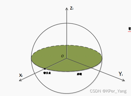
1. Inertial coordinate system
The inertial coordinate system is referred to as the i system.This coordinate system is used to obtain the attitude information of the robot in space, and it is a coordinate system strictly conforming to Newton's classical mechanics.In general, but an absolute inertial coordinate system does not exist.During the measurement of celestial bodies, the center of the earth is the origin close to the inertial coordinate system, and the Z axis is the rotation axis of the earth, which is perpendicular to the orbital plane of the earth's revolution.The X and Y axes are in the plane of the Earth's equator and are perpendicular to each other.Generally speaking, the physical quantities measured by the IMU are relative to the inertial coordinate system.The emergence of the inertial coordinate system simplifies the transformation from the world coordinate system to the carrier coordinate system.
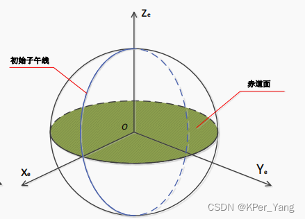
2. Earth coordinate system
The earth coordinate system is referred to as the e system. The center of the earth is the origin of the coordinate system. It is relative to the inertial coordinate system at an angular velocity  It rotates synchronously with the earth, and it is considered that the coordinate system is fixed on the earth, so the coordinate system can also be named earth fixedCoordinate System.The X and Y axes are perpendicular to each other in the equatorial plane, and the Z axis is the Earth's axis of rotation.In inertial navigation, the position information of the carrier relative to the earth is obtained by calculation, that is, the position information of the carrier in the earth coordinate system.
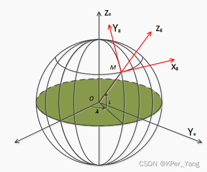
3. Geographical coordinate system
The geographic coordinate system is referred to as the g system, and it can also be called the local horizontal coordinate system. The origin of the coordinate system is located at the center of mass of the carrier, that is, the coordinate system of the earth plane.According to people's habits, the "Northeast Sky" coordinate system and the "Northeast Earth" coordinate system are usually used.The origin of the "north-east" coordinate system is the station center, the direction of the X-axis points to the north; the direction of the Y-axis points to the east; the direction of the Z-axis points to the vertical direction.The roll, pitch (pitch) and yaw (yaw) angles described in the carrier attitude are defined by the geographic coordinate system.
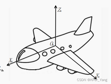
4. Carrier coordinate system
The carrier coordinate system is referred to as the b system. This coordinate system is fixedly connected to the carrier, and the center of mass of the carrier is the coordinate origin.The b system is used for motion carriers, including ships, airplanes, etc., so it is also a general term for the body coordinate system, the hull coordinate system, and the missile body coordinate system.The X axis is along the horizontal axis of the carrier to the right, and the corresponding angle is named the roll angle; the Y axis is forward along the vertical axis of the carrier, and the corresponding angle is named the pitch angle; the Z axis is upward along the vertical axis of the carrier, corresponding to itThe angle is named the yaw angle.These coordinate axes jointly form an orthogonal coordinate system that conforms to the Cartesian right-hand coordinate system. The coordinate axes are fixed in the position of the carrier, so the zero point will have a coincidence effect with the coordinate system.
边栏推荐
猜你喜欢


随机推荐
MySQL导入导出&视图&索引&执行计划
导航定位中的坐标系
OA项目之会议通知(查询&是否参会&反馈详情)
Do not add the is prefix to the variables of the boolean type in the POJO class of the Alibaba specification
iptables 流量统计
Conference OA Project My Conference
淘宝API常用接口与获取方式
Class definition, class inheritance, and the use of super
deepin v20.6+cuda+cudnn+anaconda(miniconda)
命令输出给变量
Numpy_备注
HCIP BGP neighbor building, federation, and aggregation experiments
OA项目之项目简介&会议发布
HCIP Republish/Routing Policy Experiment
图文带你理解什么是Few-shot Learning
每日sql -查询至少有5名下属的经理和选举
arcgis填坑_1
实现通用的、高性能排序和快排优化
HCIP MGRE\OSPF综合实验
sql--Users who have purchased more than 3 times (inclusive) within 7 days (including the current day), and the purchase amount in the past 7 days exceeds 1,000