当前位置:网站首页>Land cover / use data product download
Land cover / use data product download
2022-04-23 17:42:00 【Meteorite cloud】
| Product data name | Time ( year ) | Range | The resolution of the | Download address |
|---|---|---|---|---|
| FROM-GLC10 | 2017 | The global | 10/30m | http://data.ess.tsinghua.edu.cn/fromglc10_2017v01.html |
| GlobeLand30 | 2000、2010、2020 | The global | 30m | http://www.globallandcover.com/ |
| Sentinel-2 10m Land Use/Land Cover Timeseries | 2017-2021 | The global | 10m | https://www.arcgis.com/apps/instant/media/index.html?appid=fc92d38533d440078f17678ebc20e8e2 |
| ESA WorldCover | 2020 | The global | 10m | https://viewer.esa-worldcover.org/worldcover/ |
| Climate Change Initiative (CCI) Land Cover V2 | 1992 -2015 | The global | 300m | http://maps.elie.ucl.ac.be/CCI/viewer/download.php |
| OSM Land Use Data | — | — | — | Download address 1: https://api.openstreetmap.org/api/0.6/map?bbox=11.54,48.14,11.543,48.145 stay URL in , The bounding box is represented as four comma separated numbers , In sequence : Left 、 Next 、 Right 、 On (min long、min lat、max long、max lat),API Limited to approximately 0.5 Degree multiplication 0.5 Degree bounding box Download address 2: http://overpass.openstreetmap.ru/cgi/xapi_meta?*[bbox=11.5,48.1,11.6,48.2] Suitable for larger areas |
| MODIS Land Cover | — | The global | 500m | https://earthexplorer.usgs.gov/ |
| Global Land Cover Characterization (GLCC) | 1992 | The global | 1km | https://earthexplorer.usgs.gov/ |
| Global Land Cover - SHARE (GLC-SHARE) | 2013 | The global | 1km | https://data.apps.fao.org/map/catalog/srv/eng/catalog.search#/metadata/ba4526fd-cdbf-4028-a1bd-5a559c4bff38 |
| China land cover dataset (CLCD) | 1990-2019 | The national | 30m | https://zenodo.org/record/4417810#.YmOo5YVBxPY |
| Global Land Cover and Land(CLCLU 2019) | 2019 | The global | 30m | https://storage.googleapis.com/earthenginepartners-hansen/GLCLU_2019/download.html |
| Long term Global Land Change (1982 - 2016) | 1982-2016 | The global | 0.05° | https://glad.umd.edu/dataset/long-term-global-land-change |
| China's land use data | 1980-2015 | The national | — | http://data.tpdc.ac.cn/zh-hans/data/a75843b4-6591-4a69-a5e4-6f94099ddc2d/ |
| Land cover map of China | 2000 | The national | — | http://data.tpdc.ac.cn/zh-hans/data/7e61387b-d3f2-40cb-bc05-8d16e01ea72b/ |
| ESA1992-2020 | 1992-2020 | The global | 300m | https://cds.climate.copernicus.eu/cdsapp#!/dataset/satellite-land-cover?tab=form |
| National land use data ( charge ) | 1980~2020 | The national | 15m、30m、100m、250m、500m、1km | http://www.dsac.cn/DataProduct/Detail/200804 |
If other products are found , Welcome to add your comments. .
Reference website :
https://www.gisrsdata.com/data-gis-shange/
https://blog.csdn.net/qq_912917507/article/details/104291310
https://gisgeography.com/free-global-land-cover-land-use-data/
https://blog.csdn.net/Remote_Sensinger/article/details/121237432?spm=1001.2101.3001.6650.1&utm_medium=distribute.pc_relevant.none-task-blog-2%7Edefault%7ECTRLIST%7ERate-1.pc_relevant_antiscanv2&depth_1-utm_source=distribute.pc_relevant.none-task-blog-2%7Edefault%7ECTRLIST%7ERate-1.pc_relevant_antiscanv2&utm_relevant_index=2
版权声明
本文为[Meteorite cloud]所创,转载请带上原文链接,感谢
https://yzsam.com/2022/04/202204231739306857.html
边栏推荐
- uni-app黑马优购项目学习记录(下)
- Understanding and small examples of unity3d object pool
- 394. String decoding - auxiliary stack
- 31. Next arrangement
- 土地覆盖/利用数据产品下载
- Entity Framework core captures database changes
- 402. Remove K digits - greedy
- 239. 滑动窗口最大值(困难)-单向队列、大顶堆-字节跳动高频题
- Excel quickly and automatically fills the contents of a row on a blank cell
- 440. 字典序的第K小数字(困难)-字典树-数节点-字节跳动高频题
猜你喜欢
![Using quartz under. Net core -- general properties and priority of triggers for [5] jobs and triggers](/img/65/89473397da4217201eeee85aef3c10.png)
Using quartz under. Net core -- general properties and priority of triggers for [5] jobs and triggers
STM32 entry development board choose wildfire or punctual atom?
Summary of common SQL statements

Qt error: /usr/bin/ld: cannot find -lGL: No such file or directory
470. Rand10() is implemented with rand7()
470. 用 Rand7() 实现 Rand10()
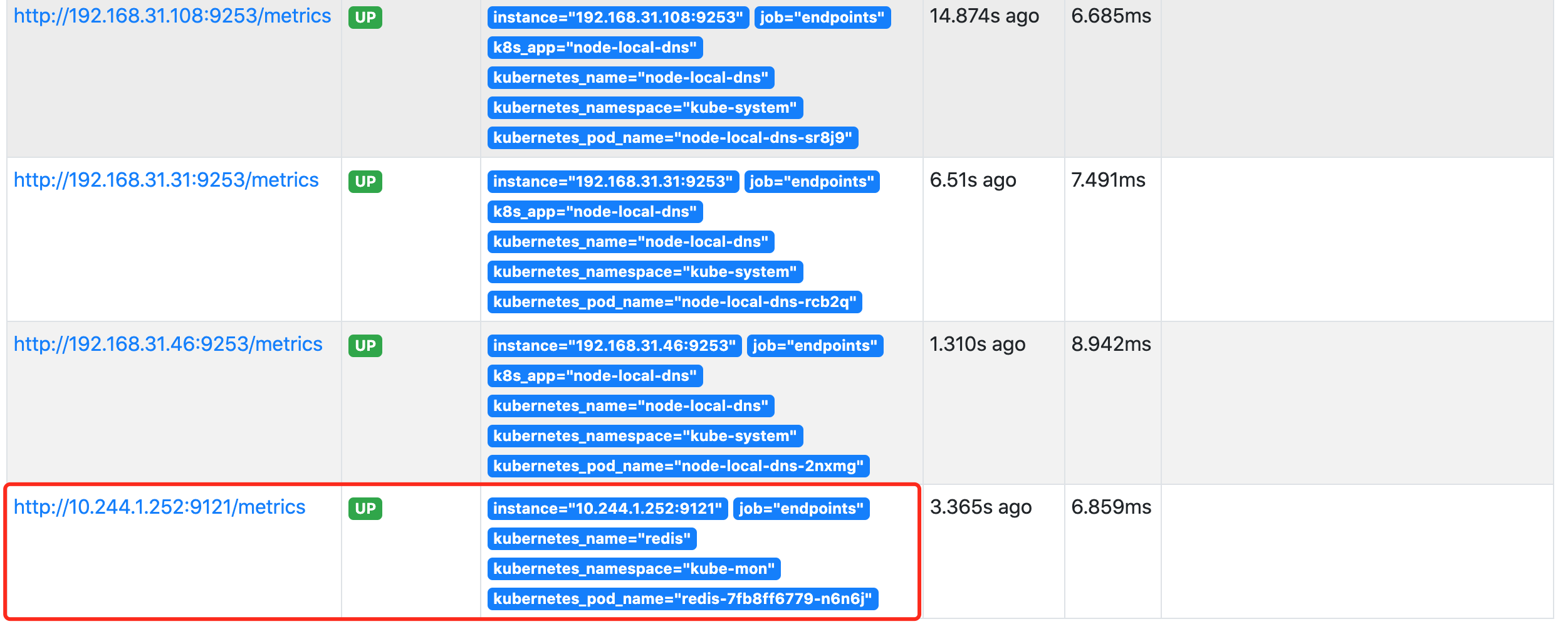
Kubernetes service discovery monitoring endpoints
![Using quartz under. Net core -- job attributes and exceptions of [4] jobs and triggers](/img/ec/43dddd18f0ce215f0f1a781e31f6a8.png)
Using quartz under. Net core -- job attributes and exceptions of [4] jobs and triggers

2022年上海市安全员C证操作证考试题库及模拟考试
![Using quartz under. Net core -- operation transfer parameters of [3] operation and trigger](/img/4e/2161fc448f4af71d9b73b7de64a17f.png)
Using quartz under. Net core -- operation transfer parameters of [3] operation and trigger
随机推荐
958. Complete binary tree test
Using quartz under. Net core - calendar of [6] jobs and triggers
102. 二叉树的层序遍历
122. 买卖股票的最佳时机 II-一次遍历
How to use the input table one-way service to send (occupy less) picture files (body transmission)? FileReader built-in object involved
198. Looting - Dynamic Planning
Qt error: /usr/bin/ld: cannot find -lGL: No such file or directory
土地覆盖/利用数据产品下载
Change Oracle to MySQL
Use of five routing guards
41. 缺失的第一个正数
01 - get to know the advantages of sketch sketch
Self use learning notes - connectingstring configuration
How to sort the numbers with text in Excel from small to large instead of the first number
常用SQL语句总结
干货 | 快速抽取缩略图是怎么练成的?
编译原理 求first集 follow集 select集预测分析表 判断符号串是否符合文法定义(有源码!!!)
Sword finger offer 22 The penultimate node in the linked list - speed pointer
For the space occupation of the software, please refer to the installation directory
Qt 修改UI没有生效